Geography
Main article: Geography of Stuttgart
Stuttgart lies in a fertile bowl-shaped valley about 900 feet (270 m) above sea level,[132][h] an hour from the Black Forest and Swabian Jura[28] on the banks of the Neckar river at 48°47′0″N 9°11′0″E 115 miles (185 km) to the west and north of Munich.[133] The city is often described as being "zwischen Wald und Reben",
or "between forest and vines" because of its viticulture and proximity
to the nearby forests. Local residents refer to the basin as the Stuttgarter Kessel, or "Stuttgart cauldron," during the summer months because of its hot and humid climate that is frequently warmer than the surrounding countryside of Württemberg.Stuttgart covers an area of 207.35 km2 (80 sq mi) and sits at elevation ranging from 207 m (679 ft) above sea level by the Neckar river to 549 m (1,801 ft) on Bernhartshöhe hill – something rather unique in large German cities. The most prominent elevated locales in Stuttgart are the Birkenkopf (511 m (1,677 ft)) on the edge of the Stuttgart basin, the Württemberg (411 m (1,348 ft)) rising above the Neckar valley, and the Grüner Heiner (395 m (1,296 ft)) at the northeast end of the city.
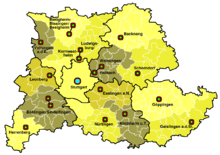
Stuttgart Region with Centers
| Mittelzentrum / Middle-Stage centers of the Stuttgart Region |
|---|
| Backnang, Bietigheim-Bissingen / Besigheim, Böblingen / Sindelfingen, Esslingen am Neckar, Geislingen, Göppingen / Herrenberg, Kirchheim unter Teck, Leonberg, Ludwigsburg / Kornwestheim, Nürtingen, |


No comments:
Post a Comment